

New Urengoy is the unofficial gas capital of Russia, a place where beautiful white nights reign. In this regard, throughout the summer, at night in this city it is as bright as day. This is due to the location of the city - in the north of Western Siberia. Also, two small rivers pass through Novy Urengoy - Tamchara-Yakha and Sede-Yakha, which divide the city into Northern and Southern regions. As it became known, its name is from the Khanty and Nenets languages: the words “Ure” and “Ngo” symbolize the “oxbow lake” and “an island on the site of the old river bed.” However, the residents of the city simply call it “Beloved Nur”.
Some experts translate the word “Urengoy” as “bald hill.” Earlier in the 50s, Gulag prisoners called this territory a “lost place”, because it was here that many years ago prisoners, on Stalin’s orders, built a railway.
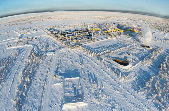
It is worth noting that today Novy Urengoy is a prosperous city in terms of economic indicators and industrial potential. Every year about 550 billion cubic meters of natural gas are produced here, where the main role belongs to the enterprises of New Urengoy.
Regarding the climate, it is worth noting that the winters here are quite long and cold. The lowest temperatures are recorded in January and February and are -21.7 and -20.1°C. Experts have noted cases when the temperature reached -45°C.
Summer in Novy Urengoy is quite short - 35 days, the hottest month is July with temperatures around +25..+30°C. There is little precipitation, but there are strong winds.
The environmental situation in the city is quite enviable, despite the developed gas industry here. The main industrial enterprises are located outside the city, household waste is regularly collected, and any landfills in the city are punishable by fines.
It is also worth noting that Novy Urengoy is also successful in terms of population. According to statistics, as of 2012, 106 thousand people live here. However, for the conditions of the Far North, this is practically a record, given the fact that at the end of the 20th century the number of Urengoy residents was not even ten thousand.
Another feature of the city is its multinationality. At the moment, more than 40 nationalities live here, most of which are Russians, Ukrainians, Tatars, Chechens and many others. The main religions are Islam and Christianity.
Geographically, Novy Urengoy is divided into 4 districts: northern and southern, which are called by the local population as “north” and “yuzhka”, as well as the districts of Limbayakha and Korotchaevo. The northern and southern regions are separated by tundra and two rivers, but represent the city itself. In turn, Limbayakha and Korotchaevo are located far from the center and were previously autonomous territorial entities. However, in 2004 they became part of Novy Urengoy. Thus, Novy Urengoy became one of the longest cities with a length of more than 80 km.
It is worth noting that the city has fairly well-developed transport links: all types of means of transport are available, with air transport remaining the most popular. Also, the railway connection and the local river port, which is a transport artery between the northern cities, are no less developed here.
The social infrastructure in Novy Urengoy is also very developed, which is represented by a large number of educational institutions for both schoolchildren and students.
You may have heard about a Russian city like Novy Urengoy: someone was passing through there, and some still live permanently today. However, if you ask a person to tell about this settlement and even show its location on the map, most will fall into a stupor. To prevent this from happening, in this article we will tell you everything about Novy Urengoy: what region it belongs to, where it is located, what its history is and what both visiting tourists and indigenous residents can pay attention to here.
One of the cities of Western Siberia: general information
The city of Novy Urengoy - what region does it belong to? To Tyumen, which, in turn, is a constituent unit of the Yamalo-Nenets Autonomous Okrug. The city of Novy Urengoy is the largest populated area in the district and one of the few that is ahead of the administrative center of its subject both in industrial potential and in population (we are talking about comparison with Salekhard). The city discussed in this article is 450 kilometers east of the latter; It is separated from Moscow, located in the northeast of the capital, by 2,350 kilometers. In addition, residents of the city of Novy Urengoy, unlike Muscovites, live in a different time zone: for example, the New Year and other holidays are traditionally celebrated 2 hours earlier. Today the city is home to about 116 thousand people. Being a key link in the largest gas-bearing region, Novy Urengoy, the location map of which will be presented below, is unofficially called the gas-producing capital of the country.
Surrounding area
On the map, Novy Urengoy is located on the banks of the Evo-Yakha River, which is a tributary of the Pura. There are also 2 other rapids flowing through the city: Sede-Yakha and Tamchara-Yakha, which conditionally divide the settlement into Northern and Southern parts. The territory of urban areas is surrounded on all sides by the Purovsky district and heavily swampy areas. In total, Novy Urengoy (which region the city belongs to and what its general current position is has already been described above) occupies an area of 113 square kilometers. The Arctic Circle already begins 60 kilometers north of it.
Climatic conditions
So, if it has now been clarified which area Novy Urengoy belongs to, it’s time to move on to analyzing provisions that have more practical significance for humans - for example, what is the situation with the weather and average temperatures? The climate of the city can be characterized as sharply continental. What does this mean? Since this settlement is located at the intersection of 2 climatic zones of the forest-tundra zone, subarctic and temperate, there is a severe winter, the duration of which reaches 9 months, and a cool summer, which lasts on average only for a period of just over 1 month. Important factors that influence weather conditions and shape the climate include the presence of permafrost, the city’s proximity to the sea, as well as the continuous circulation of Atlantic air masses. The average temperature in January is -21.7 degrees, in June - +9.1; at the same time, the relative air humidity is 78%, and the average wind speed reaches only 3.4 m/second. Frequent temperature changes in Novy Urengoy (the map of Russia helps to analyze all the conditions and factors shaping the climate) are accompanied by blizzards, blizzards, and blizzards. Most of the flat terrain of the settlement is covered with permafrost ice, which in the summer thaws to a depth of only 1 to 2 meters!

The beginning of the story
It is a pity that the facts about the development of cities and, in particular, Novy Urengoy are not indicated on the map of Russia - there is not enough space, and the purpose of these reference books is different. Few people would think of studying the historical formation of this particular settlement, and it would be in vain! The history of the city reveals a lot of interesting things: from the very beginning it was closely intertwined with the development of the Urengoy gas field, discovered in June 1966. However, in fact, the roots of the city’s formation must be sought even earlier, namely in 1949, when, by order of Stalin, the construction of a transpolar railway began in the subpolar tundra zone for the movement of trains along the Salekhard - Igarka route. It was not the plan of the builders, who mostly belonged to the rest of the thousands of camp prisoners sent to build the road, to linger at the former Urengoy trading post. However, Stalin died, the construction work was curtailed and forgotten, the built tracks were called “dead,” but for Urengoy it was a turning point: it was the once unfinished railway forks that helped drillers and seismic explorers discover deposits in these lands and quickly develop them. In January 1966, the opening of a new Urengoy structure took place here. The pioneering team was a company of employees of the seismic station V. Tsybenko, which occupied the barracks of a once abandoned camp where Gulag prisoners had previously lived.

The way forward
Subsequently, active mining continued here: in June 1966, master V. Polupanov and his team drilled the first exploration well. It was after this that a footnote appeared on the map of the country indicating the unique nature of natural gas. September 1973 was marked by the fact that on the site of a city that did not yet exist at that time, a peg was driven in with a sign and a symbolic inscription on it: “New Urengoy” (we, the descendants, now know where the city is located). In December, construction began on a settlement familiar to Russians today. The village developed rapidly, which was associated with an increase in the activity of the gas produced in it. In 1980, Novy Urengoy, previously not considered a city (to which region this place belongs and what its historical formation is, now everyone can answer) finally received the long-awaited status and was now called a city of district significance! Since 1984, gas from here began to be exported to Western Europe using the Urengoy - Pomary - Uzhgorod gas pipeline built in 1983.

In November 1984, the village of Korotchaevo came under the authority of Novy Urengoy and the city council representing it at the administrative level, and in May 1988, the village of Limbayakha. As a municipal entity, Novy Urengoy was formed only in January 1996 with reference to one of the relevant laws of the Yamalo-Nenets Autonomous Okrug, and in 2004 the above-mentioned villages ceased to exist as independent administrative-territorial elements and became part of the city of Novy Urengoy. As a result, the city with a length of 80 km turned into one of the longest in the whole world!
Serious measures
An interesting fact is that in 2012 the city actually became closed, given that there was no actual legal basis for this. Entry into the city could only be done with a special pass. Such drastic measures were needed because the crime level in this territory was approaching a critically high level. Various terrorist organizations were active here, and therefore the situation had to be resolved on an emergency basis. There is also an unconfirmed hypothesis that this practice of a permit system was introduced to regulate population migration and limit the internal and external “turnover” of residents. Be that as it may, such a system in Urengoy, whose name translated from one of the local Nenets dialects means “lost place,” lasted about six months and then was abolished.

Industry
Novy Urengoy, being a fairly young city, manages to demonstrate extraordinary industrial potential. Thus, within the settlement there are 3 pillars of the gas production industry, each of which is a subsidiary of the Gazprom company: Tyumenburgaz, Yamburggazodobycha and Urengoygazprom. They account for about 74% of all gas produced in the country! Construction work to restore railway lines is being carried out by the Yamal Railway Company. 80% of river transportation occurs at the Urengoy river port, which has dozens of ferries and tractors.
Attractions
Among the key places in Novy Urengoy, a map with the streets of which will be offered below, we can highlight the Museum of Fine Arts, a multifunctional, modern and technologically advanced station commissioned in 2015, the largest fountain in the Far North, visually reminiscent of a sail. On the roof of the Helicopter shopping center, which is designed in an eye-catching color scheme, visitors can see a model of a real rotary-wing aircraft. The city is also home to monuments and temples - real examples of architectural art and architecture (for example, the Epiphany Cathedral, built in 2015, which is the tallest building in the city).

Education
There are many universities operating on the territory of New Urengoy, including:
- branch of the Moscow State Open University;
- branch ;
- branch of the Tobolsk State Pedagogical Institute named after. DI. Mendeleev;
- branch of Tomsk State University of Radioelectronics and Control Systems;
- branch of the Moscow Open Social University (Institute) and others.
As you can see, here, in one of the cities of the Tyumen region, you can not only live, but do it successfully: study, work and make plans for the future.
Novy Urengoy: photos from space (Google Maps)
Novy Urengoy: photos from space (Microsoft Virtual Earth)
| New Urengoy. Nearest cities. Distances in km. on the map (in brackets along roads) + direction. By hyperlink in the column distance you can get the route (information kindly provided by the AutoTransInfo website) |
|||
| 1 | Urengoy | 77 (82) | IN |
| 2 | Pangodas | 103 (92) | Z |
| 3 | 139 (207) | YU | |
| 4 | Tazovsky | 178 () | NE |
| 5 | Purpe | 178 (265) | YU |
| 6 | 183 (273) | YU | |
| 7 | 199 (226) | Z | |
| 8 | Krasnoselkup | 265 () | IN |
| 9 | Yar-Sale | 274 () | Z |
| 10 | 275 (400) | SW | |
| 11 | 325 (435) | YU | |
| 12 | Aksarka | 400 () | Z |
a brief description of
Located in Western Siberia, on the river. Evoyakha, 60 km south of the Arctic Circle, 450 km east of Salekhard. Railway station (departmental, Ministry of Railways - Korotchaevo).
Territory (sq. km): 227
Information about the city of Novy Urengoy on the Russian Wikipedia site
Historical sketch
It arose in connection with the development of the Urengoy gas condensate field.
September 22, 1973 is considered the founding day of New Urengoy. On this day, geologists hammered a peg with a sign “Novy Urengoy” at the work site. In 1975, when gas workers completed drilling the first production well, Novy Urengoy was registered as a village. In 1975, the airport was built and the first technical flight was carried out. In 1977, the Surgut - Novy Urengoy railway was built.
City since June 16, 1980. The definition “new” in the name is associated with the existence of the workers’ village of Urengoy, which arose somewhat earlier on the right bank of the river. Pur, almost 100 km east of Novy Urengoy. The toponym Urengoy is explained as Nenets “deaf, dense.”
Since 1984, Novy Urengoy gas began to flow to Europe via the Urengoy - Pomary - Uzhgorod gas pipeline.
Municipal indicators
| Index | 1999 | 2001 | 2005 |
| Demography | |||
| Number of births, per 1000 population | 10.7 | 11.3 | 12.7 |
| Number of deaths, per 1000 population | 4.2 | 4.6 | 3.9 |
| Natural increase (decrease), per 1000 population | 6.5 | 6.7 | 8.8 |
| Standard of living of the population and social sphere | |||
| Average monthly nominal accrued wages, rub. | 7628 | 14692 | 30950 |
| Average housing area per inhabitant (at the end of the year), sq.m. | 16.3 | 15.9 | 14.8 |
| Number of preschool institutions, pcs. | 39 | 38 | 38 |
| Number of children in preschool institutions, thousand people | 6.2 | 5.9 | 6.2 |
| Enrollment of children in preschool educational institutions (at the end of the year), as a percentage of the number of children of the corresponding age, % | 82.8 | ||
| Number of daytime educational institutions (at the beginning of the school year), pcs. | 25 | 24 | 23 |
| Number of students in daytime educational institutions, thousand people | 19.9 | 18.6 | 15.6 |
| Number of doctors, people. | 334 | 390 | 485 |
| Number of nursing staff, people. | 1053 | 1135 | 1278 |
| Number of hospital institutions, pcs. | 5 | 4 | 4 |
| Number of hospital beds, thousand units | 1.1 | 1 | 1.1 |
| Number of medical outpatient clinics, pcs. | 7 | 10 | 13 |
| Capacity of medical outpatient clinics, visits per shift, thousand units. | 1.9 | 2.1 | 2.5 |
| Number of registered crimes, pcs. | 1862 | 1791 | 2706 |
| Persons who committed crimes were identified, people. | 1119 | 1125 | 920 |
| Economy, industry | |||
| Number of enterprises and organizations (at the end of the year), pcs. | 2286 | 2570 | 1711 |
| Number of operating enterprises by type of activity: mining (at the end of the year), pcs. | 19 | ||
| Number of operating enterprises by type of activity: manufacturing (at the end of the year), pcs. | 38 | ||
| Number of operating enterprises by type of activity production and distribution of electricity, gas and water (at the end of the year), pcs. | 54 | ||
| Volume of shipped goods of own production by type of mining (in actual prices), million rubles. | 54098.8 | ||
| Volume of shipped goods of own production by type of manufacturing (in actual prices), million rubles. | 19041.2 | ||
| Volume of shipped goods of own production by type of production and distribution of electricity, gas and water (in actual current prices), million rubles. | 2324.2 | ||
| Construction | |||
| Volume of work performed by type of activity "Construction" (until 2004 - volume of work performed under construction contracts), million rubles. | 3499.5 | 17253.1 | 14940.9 |
| Commissioning of residential buildings, thousand sq.m. of total area | 23.9 | 8.6 | 21 |
| Commissioning of residential buildings, apartments | 390 | 156 | 379 |
| Commissioning of preschool institutions, places | 0 | 0 | 0 |
| Commissioning of educational institutions, places | 0 | 825 | 0 |
| Commissioning of hospital facilities, beds | 0 | 0 | 0 |
| Commissioning of outpatient clinics, visits per shift | 0 | 0 | 0 |
| Transport | |||
| Number of bus routes (in intracity traffic), pcs. | 12 | 9 | 9 |
| Number of passengers transported by buses per year (in intracity traffic), million people. | 24 | 18.7 | 13.1 |
| Connection | |||
| Number of residential telephone sets of the city public telephone network, thousand units. | 21.5 | 23.8 | 26.2 |
| Number of payphones of the city telephone network (including universal ones), pcs. | 145 | ||
| Trade and services to the population | |||
| Retail trade turnover (in actual prices), million rubles. | 2389 | 4327 | 13085.1 |
| Retail trade turnover (in actual prices), per capita, rub. | 24153 | 43712 | 118096.1 |
| Index of physical volume of retail trade turnover, % compared to the previous year | 121 | ||
| Public catering turnover (in actual prices), million rubles. | 169.2 | 396 | 1782.2 |
| Index of physical volume of public catering turnover, % compared to the previous year | 115 | ||
| Number of stores, pavilions (at the end of the year), pcs. | 8 | ||
| Sales area of shops, pavilions (at the end of the year), sq.m. | 526 | ||
| Volume of paid services to the population (in actual prices), million rubles. | 427.7 | 864.6 | 3508 |
| Volume of paid services to the population (in actual prices), per capita, rub. | 4324 | 8734 | 31660.5 |
| Volume of household services to the population (in actual prices), million rubles. | 30.8 | 48.5 | 87.9 |
| Volume of household services to the population (in actual prices), per capita, rub. | 312 | 490 | 793.4 |
| Investments | |||
| Investments in fixed capital (in actual prices), million rubles. | 5707.6 | 8235.2 | 20961.7 |
| Share of investments in fixed assets financed from budgetary funds in the total volume of investments, % | 5.2 | 3 | 6.1 |
Data sources:
- Regions of Russia. Main characteristics of the constituent entities of the Russian Federation: statistical collection. Goskomstat of Russia. - M:, 2003.
- Regions of Russia. Volume 1. Statistical collection. Goskomstat of Russia. - M:, 2001. p. 438
- Regions of Russia. Basic socio-economic indicators of cities. 2006. Statistical collection. Rosstat. - M:, 2006. p. 277
Economy
The subsidiaries of OJSC Gazprom are Urengoygazprom and Yamburggazdobycha, which account for 74% of all gas in Russia.
Main enterprises
NATURAL GAS PRODUCTION
Urengoygazprom LLC629300, Yamalo-Nenets Autonomous Okrug, Novy Urengoy, st. Embankment, 26
Offers:
LLC "Yamburggazdobycha"
629300, Yamalo-Nenets Autonomous Okrug, Novy Urengoy, st. Taiga, 27
Offers:
TRANSPORT
JSC "Sevtyumentransput"629300, Yamalo-Nenets Autonomous Okrug, Novy Urengoy, st. Privokzalnaya, 1
Offers: Construction and railway transportation
INLAND WATER TRANSPORT
Branch "River Port Urengoy" JSC "OIRP"629300, Yamalo-Nenets Autonomous Okrug, Novy Urengoy, village. Korotchaevo
Offers: Transportation of dry cargo, oil cargo, passengers
Universities of the city
Novy Urengoy branch of the Russian New University629300, Yamalo-Nenets Autonomous Okrug, Novy Urengoy, st. 26th Congress of the CPSU, 4-G
Novy Urengoy is a medium-sized city in the Yamal-Nenets Autonomous Okrug, located on the Sede-Yakha and Evo-Yakha rivers, 452 kilometers from Salekhard. The area of the settlement is 221 square kilometers.
General data and historical facts
In the summer of 1966, the Urengoy natural gas field was discovered on the site of the modern city.
In June 1973, the Yagelnoye settlement for gas workers was founded. In June 1975, the first well was put into operation. In the same year, the village of Novy Urengoy was founded and construction of an airport began.
In September 1976, the first school in the village admitted 72 students. After 2 years, the Urengoygazdobycha organization was created.
In the spring of 1978, full-scale production and comprehensive gas treatment began at the Urengoy field.
At the end of May 1978, the first billion cubic meters of blue fuel were extracted in Novy Urengoy.
In 1980, the settlement of gas workers was transformed into a city of district significance.
In 1982, a railway was built through Novy Urengoy, which connected the city with other parts of the country.
In 1983, the main export gas pipeline "Urengoy - Uzhgorod" was built, through which gas began to be exported to European countries a year later.
In the 1980s, the villages of Korotchaevo and Limbayakha were transferred to the subordination of the city council of Novy Urengoy.
In 1996, in accordance with Law No. 34 of the Yamal-Nenets Autonomous Okrug, the municipal district of Novy Urengoy was created.
In December 2004, development of the Pestsovoye gas field began. In 2005, on the 30th anniversary of the city, an eternal flame and the first city fountain were opened.
In 2006, Memory Square was opened in the Student district of the city.
Industrial enterprises: Gazprom Dobycha Urengoy LLC, Gazprom Dobycha Yamburg LLC, Sibneftegaz OJSC, Severneft-Urengoy LLC, Urengoymontazhpromstroy OJSC, Severneftegazprom OJSC, Urengoyskaya State District Power Plant.
The city operates on Yekaterinburg time. The difference with Moscow time is +4 hours msk+4.
Telephone code of Novy Urengoy - 3494. Postal code - 629300.
Climate and weather
A sharply continental climate prevails in Novy Urengoy. Winters are very frosty and long. The average temperature in January is -20.7 degrees.
Summer is cool and short. The average temperature in July is +17.1 degrees.
Total population of New Urengoy for 2018-2019
Population data was obtained from the State Statistics Service. Graph of changes in the number of citizens over the past 10 years.

The total number of residents in 2017 is 113.2 thousand people.
The data from the graph shows a steady decrease in the population from 117,000 people in 2007 to 113,254 people in 2017.
The following nationalities live in the city: Russians - 64.1%, Ukrainians - 10.8%, Tatars - 5%, Nogais - 2.6%, Kumyks - 2%, Azerbaijanis - 2%, Bashkirs - 1.7%, Chechens - 1.1%, Belarusians - 1.1%, Moldovans - 1%, Chuvash - 0.6%, others - 5.5%.
As of January 2018, Novy Urengoy ranked 149th out of 1,113 cities in the Russian Federation in terms of population.
Attractions
1. Shopping center "Helicopter" - a modern shopping center that meets all Russian standards. The shopping center houses various restaurants and cafes.
2. Borehole Monument - the monument was erected in honor of the first well, which was drilled on June 6, 1966.
3. A monument to the first train - locomotive TEZ-3003 was installed on the 30th anniversary of Novy Urengoy in front of the railway station building.
Transport
There is a regional airport 4 kilometers from the city, from which there are air connections with major Russian cities.
There are three railway stations in Novy Urengoy, connecting the city with Yamburg, Salekhard, Noyabrsky, Kogalym, Surgut, Nefteyugansk.
Public transport is represented by 9 bus routes.
Buses regularly depart from the city bus station to Nadym, Surgut, Ufa,
origin of name
There are several versions of the origin of the name “Urengoy”. According to one version, it comes from the words “Ure” and “Ngo”. “Ure” translated from Khanty means “oxbow” (old river bed), “Ngo” translated from Nenets means island. That is, the name may mean “an island in the middle of an old river bed.”
There are versions according to which the word “Urengoy” means “bald hill”, “hill overgrown with yellow grass”, “hill overgrown with larches suitable for chum poles”.
According to another version, “Urengoy” means “lost place.” This is how the builders of the Gulag camp who laid the railway could call Urenga -. For the prisoners, this place was truly disastrous, so among the versions of the origin of the name there is this one.
Urengoy gas field
In February 1982, railway tracks were laid to Nartovaya station (on the Korotchaevo - Yagelnaya section). On April 15, the first freight train arrived at Farafontyevskaya station, named after A. A. Farafontyev, who was the chief engineer of the Chum - Salekhard - Igarka railway line project. By September 1982, the laying of the railway track reached the Novy Urengoy station, thanks to which the city was reliably connected with the “mainland”. The first 15 wagons loaded with potatoes were met here.
In 1983, the construction of the Uzhgorod gas pipeline was completed, and from the next year Urengoy gas began flowing to Western European countries. In March 1984, the doors of the city museum of fine arts opened. On November 6, 1985, the first passenger train from Novy Urengoy arrived.
In 1987, the General Plan of New Urengoy was developed, according to which by 2010 the city's population was supposed to grow to 200 thousand people. In July 1987, a highway connected Novy Urengoy with. In November, Urengoygazprom's daily gas production reached 1 billion cubic meters.
On December 5, 1987, the Oktyabr cinema opened, the first in the city. In September 1988, vocational school No. 31 accepted its first students. In September 1991, the city gymnasium was opened.
In December 2001, gas workers produced 10 trillion cubic meters of gas. In September 2003, the Korotchaevo railway station received its first passengers, and the branded Yamal train was officially launched. In December 2004, the Pestsovoye field was put into commercial production. By Law of the Yamal-Nenets Autonomous Okrug No. 107-ZAO of December 16, 2004, the villages of Limbayakha and Korotchaevo were included within the city limits.
During the celebrations dedicated to the 30th anniversary of New Urengoy, held on September 3-4, 2005, the Eternal Flame was lit on Memory Square, and the first fountain was opened in the city. The official opening of Memory Square in the Studenchesky microdistrict took place on November 4, 2006.
Today, three multi-line gas flows are being formed in Novy Urengoy - Central, Northern and Southern. Gas from New Urengoy is supplied to many regions, CIS countries and Western European countries.